| Around SGV / The World | ||||||||||||||||||||
| Mountain
Views News | ||||||||||||||||||||
| ||||||||||||||||||||
|
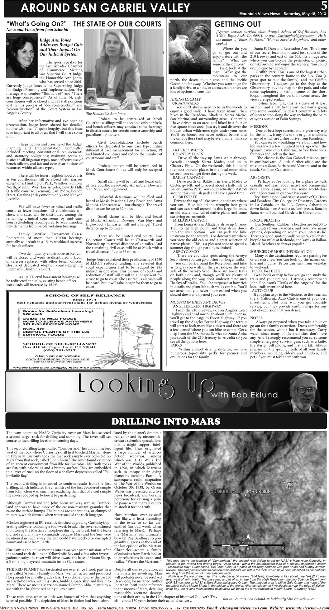
5 AROUND SAN GABRIEL VALLEY Mountain Views-News Saturday, May 18, 2013 “What’s Going On?” News and Views from Joan Schmidt GETTING OUT [Nyerges teaches survival skills through School of Self-Reliance, Box 41834, Eagle Rock, CA 90041, or www.ChristopherNyerges.com. He is the author of “Enter the Forest,” “How to Survive Anywhere,” and other books.] THE STATE OF OUR COURTS Judge Ann Jones Addresses Budget Cuts and Their Impact On Our Judicial System The guest speaker for the last Arcadia Chamber of Commerce Meeting was Superior Court Judge, the Honorable Ann Jones, who has served since 2001. Currently Judge Jones is the Supervising Judge for Budget Planning and Implementation. Her message was somber-“This is bad” and “There are huge consequences”. As of June 14, eight courthouses will be closed and 511 staff positions lost in this process of “de-reconstruction” and “re-construction” of the Court System in Los Angeles County. After her informative and eye opening presentation, Judge Jones shared her detailed outline with me. It’s quite lengthy, but this issue is so important to all of us, that I will share some of it. The principles and priorities of the Budget Planning and Implementation Committee included meeting constitutional requirements and statutory obligations; maintain access to justice in all litigation types, most effective use of bench officers, and fair and even distributions of resources within all case types. There will be fewer neighborhood courts as ten courthouses will be closed with narrow exceptions: Huntington Park, Whittier, Pomona North, Malibu, West Los Angeles, Beverly Hills (1 traffic court will remain), San Pedro, Beacon Street, Catalina (2 days/month only) and Kenyon Juvenile. We will have fewer criminal and traffic courts at fewer locations: 12 courthouses will close, and cases will be distributed among the remaining criminal courtrooms by mid-June; court scheduling reconfigured to accommodate new demands from parole violation hearings. Family Law/Civil Harassment Cases- Redirection of more than 10,000 hearings annually will result in a 15+% workload increase for bench officers. Two delinquency courtrooms at Kenyon will be closed and work re-distributed; a layoff of referees replaced with other bench officers; closure of dedicated adoption courts excepting Edelman’s Children’s Court. As 10,000 civil harassment hearings will be redirected annually, existing bench officer workloads will increase by 15+%. Probate to be centralized at Mosk Courthouse-filings will be accepted only at Mosk, and bench officers may conduct some hearings in district courts for certain conservatorship and guardianship matters. Civil Consolidations include bench officers be dedicated to one case type; utilize differential case management for collection, PI and limited civil cases and reduce the number of courtrooms and staff. Probate matters will be centralized in Mosk Courthouse-filings will only be accepted there. Small claims will be filed and heard only at five courthouses-Mosk, Alhambra, Downey, Van Nuys, and Inglewood. Unlawful detentions will be filed and heard at Mosk, Pasadena, Long Beach and Santa Monica. (Lancaster will not change) The travel distance can be up to 32 miles. Small claims will be filed and heard at Mosk, Alhambra, Downey, Van Nuys and Inglewood. (Lancaster will not change) Travel distance up to 25 miles. There will be limited civil courts. Two Collection Courts will be at Chatsworth and Norwalk-up to travel distance of 46 miles. And the remaining civil cases will be at Mosk with a travel distance of up to 66 miles. Judge Jones explained their predicament of $530 MILLION reduced funding. She revealed that court expenditures had to be reduced by $85 million in one year. This closure of courts and reduction of staff will result in a longer wait for a case to go to court. She assured us all cases will be heard, but it will take longer for them to go to court. Where do you go to get out and enjoy nature with the family? What are some of the options? First, look at the map! We’ve got the mountains to our north, the desert to our east, and the Pacific Ocean not far away. Whether you want to go for a family drive, or a hike, or an excursion, there are lots of options to consider. HIKING LOCALLY URBAN WALKS You don’t always need to be in the woods to enjoy a good walk. I have taken many urban hikes in the Pasadena, Altadena, Sierra Madre, San Marino, and surrounding areas. Generally, I have driven to an area, and hiked in a four or five square block area. Just try it and discover the hidden urban wilderness right under your nose. You’ll see homes you never noticed before, and the unique flora (and maybe even fauna) that’s so common here. FOOTHILL WALKS CHANTRY FLATS Drive all the way up Santa Anita through Arcadia, through Sierra Madre, and up to Chantry Flats. On the weekends, this is one of the most popular places in the local mountains, so see if you can get there during the week. BAILEY CANYON Drive north on Baldwin in Sierra Madre to Carter, go left, and proceed about a half-mile to Bailey Canyon Park. You could actually just stroll around this smallish park and have a good time. COBB ESTATE Drive to the top of Lake Avenue and park where you can. Hike behind the wrought iron gates and you can stroll around in this large flatlands, an old estate now full of native plants and some surviving ornamentals. MILLARD CANYON From Loma Alta in Altadena, drive up Chaney Trail to the high point, and then drive down into the river bottom. You can park and hike upstream (to the waterfall) or downstream where you view the old cabins and a great selection of native plants. This is a pleasant spot to spend a summer day, though parking is limited. ARROYO SECO There are countless spots along the Arroyo Seco where you can go on short or longer walks. You can park around the Rose Bowl, and hike as long as you wish up the east side, or the west side of the Arroyo Seco. There are horse trails on both sides and, though you’ll see plenty of people along the way, don’t underestimate such “backyard” walks. You’ll be surprised at how rich in details and plant life such walks can be. You’ll see areas that you never knew existed when you slowed down and opened your eyes. MOUNTAIN HIKES AND DRIVES ANGELES CREST HIGHWAY From the 210 Freeway, exit on Angeles Crest Highway and head north. In about 10 miles or so, you’ll get to the Angeles Forest Highway. If you travel up the Angeles Forest Highway, the terrain will start to look more like a desert and there are a few turnoff where you can hike or camp. Get a map from the U.S. Forest Service on Santa Anita just south of the 210 freeway in Arcadia so you see all the options here. PARKS Within a short driving distance, we have numerous top-quality parks for picnics and excursions for the family. Santa Fe Dam and Recreation Area. This is one of our secret locations located just south of the 210 freeway and east of the 605. It’s a huge area where you can bicycle the perimeter, or picnic, or hike around and enjoy the scenery. You could even picnic by the water. Griffith Park. This is one of the largest urban parks in the country, home to the L.A. Zoo (a great spot to take the family), and the Griffith Observatory. I suggest go to the shop at the Observatory, buy the map for the park, and take some exploratory hikes on some of the short loops throughout the park. In some areas, the views are spectacular. Joshua Tree. OK, this is a drive of at least an hour and a half to the east, but you’re going into some wonderfully desert country, with lots of spots to stop along the way, including the palm canyons outside of Palm Springs. MISSIONS One of best kept secrets, and a great day trip for the family, is any one of the original missions, many of which are a short drive from Pasadena. You can see how buildings were built, and how life was lived a few hundred years ago when the Spanish came into California, before there were freeways and Jack in the Box. The closest is the San Gabriel Mission, just in our backyard. A little further afield are the missions at Santa Barbara and Ventura, and to the south, San Juan Capistrano. ARBORETA Perhaps you’re looking for a place to walk casually, and learn about native and ornamental floral. Once again, we have some world-class outing locations in our own backyard. Try Huntington Gardens just south of Cal Tech and Pasadena City College, or Descanso Gardens in La Cañada, or the L.A. County Arboretum down Baldwin on Arcadia or, further east, Rancho Santa Anita Botanical Gardens in Claremont. LOCAL BEACHES Our Southern California beaches are but 30 to 45 minutes from Pasadena, and you have many options, depending on where your interests lie. There are good spots to walk on piers, eat lobster, bicycle for miles at Redondo, and kayak at Balboa Island. Beaches are always popular. SOURCES OF MORE INFORMATION Many of the destinations require a parking fee or an entry fee. You can look up the names on- line and inquire. Prices can vary from weekday to weekend. BOOK for HIKES Get a book or map before you go and study the trails and your options. I strongly recommend John Robinson’s “Trails of the Angeles” for the local trails mentioned here. AUTO CLUB If you plan to go to the Missions, or the beaches, the S. California Auto Club is one of your best investments. Not only will you get roadside service, but they provide custom maps for any sort of excursion that you desire. NOTES Always go prepared when you take a hike or go out for a family excursion. Dress comfortably for the season, with a hat if necessary. Carry water, since many of the trail sites don’t have any. And I strongly recommend you carry some simple emergency survival gear, such as a knife, fire starter, cell phone, and first aid kit. Always prepare for the specific needs of all your family members, including elderly and children, and pets if you must take them with you. The Honorable Ann Jones DRILLING INTO MARS The team operating NASA’s Curiosity rover on Mars has selected a second target rock for drilling and sampling. The rover will set course to the drilling location in coming days. This second drilling target, called “Cumberland,” lies about nine feet west of the rock where Curiosity’s drill first touched Martian stone in February. Curiosity took the first rock sample ever collected on Mars from that rock, called “John Klein.” The rover found evidence of an ancient environment favorable for microbial life. Both rocks are flat, with pale veins and a bumpy surface. They are embedded in a layer of rock on the floor of a shallow depression called “Yellowknife Bay.” The second drilling is intended to confirm results from the first drilling, which indicated the chemistry of the first powdered sample from John Klein was much less oxidizing than that of a soil sample the rover scooped up before it began drilling. Although Cumberland and John Klein are very similar, Cumberland appears to have more of the erosion-resistant granules that cause the surface bumps. The bumps are concretions, or clumps of minerals, which formed when water soaked the rock long ago. Mission engineers at JPL recently finished upgrading Curiosity’s operating software following a four-week break. The rover continued monitoring the Martian atmosphere during the break but the team did not send any new commands because Mars and the Sun were positioned in such a way the Sun could have blocked or corrupted commands sent from Earth. Curiosity is about nine months into a two-year prime mission. After the second rock drilling in Yellowknife Bay and a few other investigations nearby, the rover will drive toward the base of Mount Sharp, a 3-mile-high layered mountain inside Gale crater. THE RED PLANET has fascinated me ever since I took part in a play called “A Funny Family on Mars,” written, acted, and produced (for parents) by my 4th-grade class. I was chosen to play the part of an Earth-boy who, with his sister, builds a space ship and flies it to Mars. There we meet a Mars-boy named Cumbo Abba, played by a kid with the brightest red hair you ever saw! Those were days when so little was known of Mars that anything seemed possible. The depiction of Mars in fiction had been stimulated by the planet’s dramatic red color and by nineteenth- century scientific speculations that it might support intelligent life. Thus originated a large number of science- fiction scenarios, among which was H. G. Wells’ The War of the Worlds, published in 1898, in which Martians seek to escape their dying planet by invading Earth. A subsequent radio adaptation of The War of the Worlds on October 30, 1938, by Orson Welles was presented as a live news broadcast, and became notorious for causing a public panic when many listeners mistook it for the truth. Have Martians ever existed? Not likely, at least according to the evidence so far unearthed (an odd word, when referring to Mars). Perhaps the “Martians” will ultimately be what Ray Bradbury so poignantly suggests at the end of the last episode of his Martian Chronicles—where a family of colonists from Earth look at their reflections in a canal and realize, “We are the Martians!” Despite all our exploration, all the mysteries involving Mars will probably never be resolved. Here’s one, for instance: Author Jonathan Swift made reference to the moons of Mars, detailing reasonably accurate descriptions of their orbits, in the 19th chapter of his novel Gulliver's Travels— about 150 years before their actual discovery. You can contact Bob Eklund at: b.eklund@MtnViewsNews.com. This map shows the location of "Cumberland," the second rock-drilling target for NASA's Mars rover Curiosity, in relation to the rover's first drilling target, "John Klein," within the southwestern lobe of a shallow depression called "Yellowknife Bay." Cumberland, like John Klein, is a patch of flat-lying bedrock with pale veins and bumpy surface texture. The bumpiness is due to erosion-resistant nodules within the rock, which have been identified as concretions resulting from the action of mineral-laden water. North is to the top of the map. The scale bar is 50 meters (164 feet). Cumberland lies about nine feet (2.75 meters) west of John Klein. The base map is part of an image from the High Resolution Imaging Science Experiment (HiRISE) camera on NASA's Mars Reconnaissance Orbiter. The mapped area is within Gale Crater and north of the mountain called Mount Sharp in the middle of the crater. After completion of investigations near the edge of Yellowknife Bay, the rover's main science destination will be on the lower reaches of Mount Sharp. Courtesy NASA | ||||||||||||||||||||
| |